
Before the Taiwanese bolt has blown up (updated)
February 15, 2021 (8 maps)
By French general (ret) Daniel Schaeffer
Member of the French think tank Asie21 (www.asie21.com)
(Reproduction authorized by any interested media; please quote the present source)
It is now internationally known that against wind and tide China maintains its claim on almost the whole South China Sea, that is to say around 80 to 90% of a marine space whose surface approximately equals that of the Mediterranean Sea. This claim is delimited by a nine dashed line, which originated in 1947, when China was still under nationalist rule[1]. However, this line was declared « without lawful effect », therefore illegal, by The Hague Permanent Court of Arbitration (PCA) in its ruling dated July 12, 2016. The sentence pronounced on this date comes after three years during which five duly accredited judges diligently and thoroughly conducted the examination of a Memorial submitted by the Philippines on March 30, 2014[2]. To do so Manila relied on Article 287 and Annex VII of the United Nations Convention on the Law of the Sea (UNCLOS), which codify the conditions for initiating an arbitration procedure with an internationally recognized body. The reasons for the approach is that, after many years of palaver with Peking, Manila is tired of seeing Chinese operating and even establishing settlements in its exclusive economic zone (EEZ), in full contravention with the provisions of the UNCLOS.
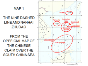
THE NINE DASHED LINE AND NANHAI ZHUDAO Daniel Schaeffer Asie21
But, China persists in rejecting the award pronounced[3] and continues in multiple ways to strengthen its hold over this space delimited by the nine dashed line, an area it calls Nanhai Zhudao (南海群岛), or « Island Group of the South China Sea ». This « group » does not only cover all the islands and other rocky basements that dot this sea, all in dispute between China and several other riparians, Vietnam, Malaysia, Brunei, Philippines, but also cover all the waters which, from these rocky grounds extend to the limits of the territorial seas of the latter and those of Indonesia.
The hydrocarbon stake
Since the problem has existed, many observers consider that the persistence of China’s ambitions is linked to its will to grab the hydrocarbon wealth contained in the subsoil of the continental shelf that surrounds the central South China Sea, the latter being a large ellipse of high sea whose depth decreases regularly from 800 to 3,000 meters. If we look at the Chinese coercive activities carried out intermittently, sometimes intensely, against Vietnam, Malaysia, the Philippines and Indonesia in their respective EEZs since 2006, wherever the Chinese claim overlaps them[4], one could conclude that it is indeed the aforesaid riches that China wants to catch for itself alone.
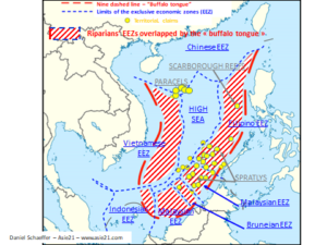
Map 2 – Overlap of the riparians’ EEZs by the Chinese claims
The fishery resource stake
Like some other analysts, one can also argue that the tyranny of China is linked to the country’s needs for fishery resources. As a matter of fact, every year, from May 1 to August 16, Peking imposes a moratorium on fishing in the South China Sea, north of the 12th parallel. The purpose of it is to allow the renewal of species, overexploited in this area. The intention is laudable, but the decision is taken arbitrarily without any consultation with the other coastal States, all of whom are primarily concerned. It is all the same for two other areas, even if defined somewhat differently in the East China Sea and throughout the Taiwan Strait[5]. On these last two marine areas the moratorium is even extended until September 16. In addition, and in the regular season of activities, the Chinese fishing fleets, part of which are naval militias, do not hesitate to go and cast their nets in the EEZs of the four countries concerned, as well as in the Indonesian’s one.
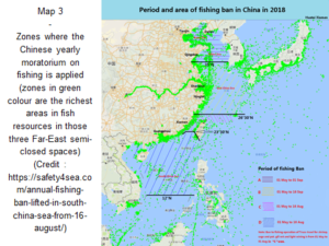
(Credit: https://safety4sea.com/annual-fishing-ban-lifted-in-south-china-sea-from-16-august/)
The stake of the commercial artery and its security
We could also say that it is to protect its convoys of supplies of hydrocarbons, raw materials and various imported products, which pass through this segment the South China Sea is as a prolongation of the general commercial maritime line of communications coming from the Indian ocean, that Beijing intends to exercise there the right of the State law enforcement at sea. That sounds logical since China considers Nanhai Zhudao as its territorial sea. Moreover, in order to maintain the fiction, it is not the People’s Liberation Army Navy (PLAN) which is entrusted with this mission of security and control of international navigation in situ, but the coast guards, a paramilitary force whose many means, ships and armament, are somewhat equivalent to those of PLAN. The coast guard’s response capacity was enhanced on January 22, 2021 with the enactment of the “Law on Maritime Police of the People’s Republic of China”. This law came into force on February 1 and will apply « in and over the sea areas under the jurisdiction of the People’s Republic of China » (article 3 of the law). There is no need to be a great scholar so as not to be fooled by such a vague formulation. China has already published enough texts on the administration of Nanhai Zhudao from the quasi-prefecture established since July 2012 on Woody island in the Paracel archipelago. The application of this new law shall not fail to provoke crises locally, sometimes likely to degenerate up to a paroxysmal level. The coast guards now have the power to use their weapons, handguns and onboard ones, against those who shall be considered offenders, whether local or foreign ones. They will even be able to dismantle facilities that shall be determined as illegal throughout the area, including on disputed uninhabited rocky sites.
The strategic reason of the Chinese irredentism
In short, dispute over the islander micro-territories, targeting hydrocarbons, attempt to establish a quasi-monopoly on fishing, desire to exercise the right of the State law enforcement at sea over the entire claimed area, are by no way the underlying reasons that support China in its desire not to give up its control over the South Sea. These reasons are only the supports of those afore mentioned stakes, important stakes indeed, but only stakes. The deep, essential reason for such a Chinese pugnacity is strategical. Beijing wants to be able, under the best possible conditions of security, to approach the American coasts with its nuclear submarine missile launchers (SSBNs), the Jins, at an optimal firing distance for its Julang II ballistic missiles, while waiting for the next generation Tang-class submarines and Julang III missiles to become operational. Let us recall, for whom this could possibly be useful, that these submarines and these missiles are not dedicated to attack but to retaliate. To use the terminology in force they are dedicated to a second-strike, whether the United States, or any other country which also masters the nuclear weapon capabilities, as India for example, would decide to strike first.
But now, with the current performances of Julang II, the maximum range of them being of 7,200 kilometers, they could not even reach Hawaii, nor Alaska, should they be fired from the depths of the South China Sea. Because of those limits of capabilities today, the Chinese submersibles are mechanically forced to sail out of this sea if they want their missiles to strike the west coast of the United States at least. To hit these targets, undoubtedly already listed by the Chinese High General Command, the Jins would have to sail far away ahead, at least as far as the Emperor – Hawaii Ridge, coincidentally defined as China’s third line of defense.
For the moment being, the first problem facing these SSBNs is their deployments from their home-port of Sanya, in the south of the island of Hainan. Detectable as possible or probable submarines by aircraft equipped with specific systems as soon as they leave their harbour, they may also be detected acoustically, as long as they have not reached a safe depth of immersion. Indeed, despite the enormous progress performed in the domain, when one compares with the 90 decibels of the general ambient noise of the oceans, the noise generated by the Jin could still be, according to different sources, between 110 and 140 decibels. But these SSBNs must first cover a little bit less than one hundred kilometers in the neritic zone where the water depth gradually declines up to 200 meters[6] as it is on the edge of the continental shelf, before plunging into the deep sea. Therefore, even accompanied by a security escort when departing for their patrols, they can be easily detected along their primary routes, both by air and by naval means, before they can dilute into black waters. This area of vulnerability at the exit of Sanya explains why it is a privileged sector chosen by the American air maritime patrols, performed with P3 Orion from 2001, P8-A Poseidon from 2013. They sometimes may come as close as 30 nautical miles from the coastline of Hainan, that is to say less than 18 miles from the island’s legal territorial sea limit.
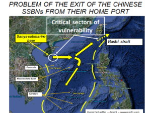
Map 4 – the problems of the exits of the Chinese SSBNS out of their home ports and of the South China Sea.
At the end of their in depth voyage towards the Pacific, the Jin must then cross Bashi Strait, where in peacetime, according to the rule enacted by the UNCLOS, they are compelled to transit on surface. In reality and logically they would rather cross diving there and are probably already doing so today. However, in the Bashi Strait the corridor is narrow since several Filipino islets loosely lock it. It is therefore easy for an enemy to position there the necessary quota of detection means in order to monitor the exits to the Pacific. They could also transit through Luzon strait, South of Bashi strait, but doing so they would cross the Filipino territorial sea.
The Chinese efforts to shape the South China Sea into a sanctuary
Given the existence of all these areas of vulnerability, the essential problem for the Chinese Jin is therefore not to be spotted all along their route inside the South China Sea. In these conditions it is vital for them to be able to limit, even eliminate, or counter if possible, all the means of identification that the opposing parties could align against them, that is to say those from the United States and their allies, as are Japanese and Australians, incidentally Indians, even French, British, Canadians. It is therefore in the interest for the Chinese to succeed in limiting the activities of all those troublemakers in the South China Sea, and above all to try to prevent them from coming in. This is the fundamental, strategic objective of the Chinese will to shape this sea into a sanctuary. In July 2011[7] professor Tetsuo Kotani, special researcher at the Okazaki Institute, in Tokyo, put forward a thesis identical to that one already developed by the present author in October 2010[8]. Leszek Buszynski, professor at the Australian National University, met on several occasions, says that the Chinese position is reminiscent to that the Soviets took when they decided to erect the seas of Okhotsk and Barents as « bastions ». All these ideas are quite identical to that of a sanctuary. It is also comparable to the ideas of some other Anglo-Saxons researchers who depict the Chinese behaviour as an application of Monroe doctrine to the South China Sea, in order to impose Peking’s supremacy there. We must add to all that the will to entirely dominate the Taiwan Strait as well as a huge swath of the East China Sea, on the grounds that China’s natural continental shelf extends up to the edge of the Okinawa Trench.
There it is the essential reason why Beijing is doing everything in its power to succeed in its plan of isolation of the South China Sea and to put in check the attempts of the United States and its allies to come in. As for the countries of Southeast Asia, which barely manage to make their weak voice heard, yet primordial, they are compelled, because of geography, to play the role of future collateral victims of potential armed clashes between the two giants.
Everything that China is currently deploying in the South China Sea and is still planning to display is in line with the intended purpose. They are:
– denial of the PCA ruling;
– refusal to give up the nine-dashed line;
– enacting the new law on maritime police with the strengthening of coast guards’ power;
– denunciation of the American activities of presence in all their forms, the most intrusive of which are the operations for the freedom of navigation (FONOPs);
– criticism of the joint allied naval exercises carried out in this sea;
– threats against the United States planes if they do not put an end to their overflights;
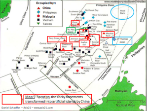
– reinforcement of the militarization of the Paracel Islands and, in the Spratlys, of the completely artificial platforms of Johnson South, Gaven, Cuarteron, Kennan, Hughes, Subi, Fiery Cross and Mischief reefs[9], each of the three latters having been equipped with one 3,000 meter long airstrip, all eight ones having radars, anti-aircraft and anti-ship missiles installed;
– project, ready to be implemented at any time, of transformation of Scarborough reef into an artificial platform, identical to that on Mischief reef;
– installation of a « high seas information network » between Hainan, the Paracels and the Spratlys, made up of automatic stations, fixed or floating, for monitoring the sea and the air, with radars, laser sensors and infra –red rays;
– Installation of a « great submarine wall », a network of sonars distributed all over the seabed, somewhat similar to the American SOSUS system[10];
– creation of a dual underwater center for collection and centralization of information;
– project to set up in hadal zone, in Manila trench, logically in Bashi Strait[11], an automatic « robotic colony » dedicated to detection;
– threat of creation of an air defense and identification zone (ADIZ) above Nanhai Zhudao which, thus matching with the outline of the nine-dashed line, would create, in the strict sense of international law, an entirely Chinese airspace;
– multiplication and densification of naval and air exercises throughout the area;
– increased testing of DF-21D and DF-26 anti-ship ballistic missiles between Hainan and the Spratlys;
– arrival in the missile panoply of the anti-ship hypersonic glide vehicle missile DF-17.
All these efforts by Beijing are lead with the aim to induce a feeling of weariness among its adversaries and drive them in giving in, to make them abandon their operations of active presence, not only in the South China Sea, but also in the Taiwan Strait and the East China Sea, and thus force them to leave those three marine spaces. Should China succeed in that scheme, that would be a magnificent illustration, if ever, of one of the principles enacted by the great ancient Chinese strategist, Sun Zi: « The best know-how is not winning a hundred victories in a hundred battles, but rather defeating the enemy without fighting ”.
5 rocky basements5 rocky basements
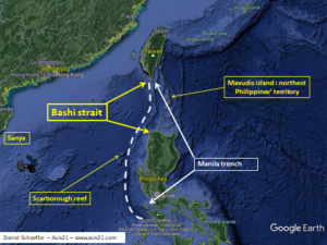
Map 6 : Bashi strait and potential area of settlement of a « robotic colony »
It is obvious that when the new generations of SSBNs and missiles, Tang and Julang-3, will be operational, in two to four years a priori, the situation will be completely changed since, with a possible range of 12,000 kilometers, the Julang- 3 would have the capability to reach the west coast of the United States, and a fortiori Alaska, without being forced out of the South China Sea. But, even if they were no longer required to do so, the fact is that the problem of their vulnerability would remain the same as today, all along the phase of their exit from the port up to the suitable moment for diving into the depths. This is why, even with the emergence of the new generation of second strike equipment, the concern of the Chinese will remain to be able to achieve the “sanctuarization” of this South Sea.
Ban foreign navies from entering the South China Sea
In this context, the ideal would be that foreign navies considered as hostile could be banned from entering this sea. This is why in the Chinese are implementing a combined strategy adapted to the concepts of anti-access, area deniel (AA/AD or A2/AD) and forward defense. To do this, they are aligning conventional air assets, numerous naval units that can be deployed in the Pacific, such as nuclear attack submarines, six in number, and aircraft carriers, the third of them being under construction, and two types of anti-ship ballistic missiles, the DF-21D and DF -26. In addition, since 2019, a hypersonic glide vehicle missile, the DF-17 has arrived in the panoply. Deployed by the rocket army, all three are said to be anti-ship missiles, as they are known to be possibly guided onto large mobile targets, such as aircraft carriers. If DF-21D range is limited to 2,000 kilometers maximum, DF-26 for their part, with their 4,000 kilometers range capabilities, can batter the Marianas arc, this arc on which the second Chinese line of defense is defined, but also where the large American base, Guam, is located. These capabilities are supplemented with those of the DF-17 whose range would be between 1,800 and 2,500 kilometers. Thus, faced with a naval enemy coming from the Pacific, the Chinese now have, without even being compelled to bring their DF-26s close to the continental seashore, a triple dome of strike over the entire Philippine Sea, between the Marianas and the coasts of the Japanese and Filipino archipelagos[12]. Moreover with DF-17s the Chinese could gain in reach since these missiles can be carried by and launched from strategic Xian H-6K bombers.
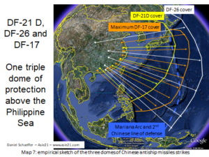
7 Empirical sketch of the three domes of Chinese anti-ship missiles strikes
Blow up the Taiwanese lock
However it is not about focusing on the South China Sea only. One can even try to assess that once Taiwan is reconquered, if ever it could be, the litigation problems in the South China Sea might even be resolved, at least in part. Quite simply because from Taiwan the security problems the Jins are facing today in the South China Sea as long as they have not reached the Pacific would disappear. And it will be the same thing for the Tangs, even if there should be no need for them to get out from that sea to apply a strike. Quite simply because after having seized the Taiwanese place, the communist conquerors would have the capacity to develop a major military port on the east coast of Taiwan, facing the Pacific. There are already many small sites that can be completely reconfigured into large naval bases, even if that would mean tearing down large parts of mountain behind in order to gain the necessary enlarged areas. In the Spratlys the savage reclamation of the islets and sea-shoals operated by China between 2012 and 2017 to transform them into operational military artificial platforms shows that the Chinese are in no way afraid by the gigantic potential tasks to be accomplished: when « Yugong moved the mountains » tells the Chinese legend.
For which interest? Quite simply because, for nearly 200 kilometers all along this eastern coast, the sea depths immediately reach the bathyal level almost everywhere: at 7 kilometers from the shore, the seabed already reaches 1,300 meters. In other words, an SSBN leaving the redeveloped port of Su Ao, Hualien, Taitung or Chenggong[13] would slide almost instantly inside the abyss within immediate reach, without any real risk of being spotted. In Hualien, the main port on this coast, the Chinese might even be able to create an underwater channel to limit, or even eliminate, the problem of the short exit out of the port. Motivated by a cold resentment, they would have the capacity to achieve this.

8 One triple dome of protection
Map 8 : Potentiality of transformation of some Taiwanese harbours into naval bases
Conclusion
This is why, to prevent such a hypothesis from happening one day, the United States has no interest in the Chinese blowing up the Taiwanese lock, this lock which closes the chain of the archipelagos of the China Sea from the East, that of the Ryukyus, and the succession of the archipelagos of the South China Sea that are the Philippines, Borneo and Indonesia to the Strait of Malacca, all these archipelagos that block the way for the Chinese navy towards the Pacific and compel it to pass through all these bottlenecks that the different straits are. This is why, vis-à-vis Taiwan, the Americans have every interest in carrying out a subtle, while remaining firm however, activity of support to the island without, because of the heavy hands they are sometimes capable, risking to awaken Beijing’s fury and tempt it to embark into a conquest by force. This is the threat that Beijing has increasingly posed near and around the island for almost two years now.
Mots-clés
South China Sea, Taiwan, Bashi strait, East China sea, China, United States, Japan, Australia, United nations convention on the law of the sea, UNCLOS, Philippines, Manila, Vietnam, Malaysia, Brunei, Indonesia, permanent court of arbitration, PCA, The Hague, ruling, SSBN, Sanya, Hainan, DF-21, DF-26, DF-17, P3-Orion, P8-Poseidon, Nanhai Zhudao, nine-dashed line, economic exclusive zone, EEZ, fishing ban, continental shelf, Paracels, Spratlys, Scarborough reef, Woody island, coast-guard, Manila trench, Okinawa trench, People’s Liberation Army Navy, PLAN, submarine, Jin, Julang-II, Tang, Julang-III, Hawaï, Mariana arc, Guam, French, Canadian, British, Tetsuo Kotani, Okasaki institute, Okhotsk, Barents, bastion, Monroe doctrine, FONOP, Johnson South, Gaven, Cuarteron, Kennan, Hughes, Subi, Fiery Cross, Mischief, SOSUS, air defense and identification zone, ADIZ, Sunzi, Yugong, Su Ao, Hualien, Taitung, Chenggong, Pacific, Malacca strait, Borneo, Ryukyu
[1] Cf. Map 1 attached. Pay attention to the fact that Zhongsha qundao, archipelago of the Middle, is sometimes improperly translated “Macclesfield bank” by some international media. Macclesfield bank is only one part of zhongsha qundao
[2] https://pcacases.com/web/sendAttach/1504 and http://www.southchinaseanewstoday.com/2015/10/30/full-text-permanent-court-arbitration-ruling-ph-case-vs-china/3/
[3] https://www.pcacases.com/pcadocs/PH-CN%20-%2020160712%20-%20Award.pdf
[4] See map 2 – the overlap of riparians’ EEZs by the Chinese claims
[5] See maps 2 and 3 and https://www.asie21.com/2019/05/17/mers-de-chine-moratoire-chinois-sur-la-peche/
[6] See map 4 – the problems of the exits of the Chinese SSBNS out of their home ports and of the South China Sea.
[7] https://thediplomat.com/2011/07/why-china-wants-the-south-china-sea/
[8] Mer de Chine méridionale : une sanctuarisation chinoise, Revue de défense nationale, 19 octobre 2010, at https://www.defnat.com/e-RDN/vue-tribune.php?ctribune=30
[9] See map 5 – the rocky sites transformed by China into artificial militarised islands
[10] SOund SUrveilance System
[11] See map 6 – Bashi strait and potential area of settlement of a « robotic colony »
[12] See Rough sketch on map 7 – the three domes of Chinese antiship ballistic strikes up to the Mariana arc
[13] See map 8 – some Taiwanese harbours possibly convertible into naval bases.